Friday, June 8, 2012

Hyde Park Landing, NY


Trip Day:
     96
Latitude:
  41°47.35 ' N 
Locks Today:
0
Miles Today:
     21 
Longitude:
073°56.86' W
Locks Total:
8
Total Miles:
1,873
Location:
Hyde Park Landing,  NY


Nestled behind Pollepel Island, we awaked to this view this morning.  We only had four miles to travel to Torches Marina/Restaurant, in Newburgh, where we had arranged to meet Dick and Sandy who drove 4 hours from Pennsylvania.


Dick (right) and Ron were roommates at the Phi Gamma Delta Fraternity house at UF a few years back.  Through Dick we met Sandy who was his  childhood friend from Clearwater.  Sophie rounded out the group. 

 
As one might guess, the conversation went something like this,
 “Do you remember .  .  .?”  They talked about cars, boats, road trips, family, caring for aging parents and how we got from then to now.  Dick’s wife Martha is from Sarasota, and as a sidebar, her father was the doctor who delivered Jean Marie Cash in 1947—LOL!  Our few hours together brought back many memories and promises to renew our friendship and stay in touch. 
 
As we traveled north today the hillsides were more populated and we seem to have left behind the Appalachian Mountain Range.  After a couple of hours we watched storm clouds build and the sky blacken bringing a wall of rain, high winds and whitecaps.  Visibility was zero—thank goodness for the chart plotter!  The good news was it lasted less than ten minutes.
We ended the day on a mooring at Hyde Park Landing which is just down the hill from The Vanderbilt Mansion and National Park.  Shortly after picking up the mooring pennant, Pete rowed out to greet us and collect the fee.  It turns out Pete’s grandfather, an Italian immigrant, purchased this waterfront strip of land from the railroad, Pete now manages the moorings and lives at the top of this hill. 

Thursday, June 7, 2012

Pollepel Island, NY


Trip Day:
     95
Latitude:
  41°27.03 ' N 
Locks Today:
0
Miles Today:
     10 
Longitude:
073°59.19' W
Locks Total:
8
Total Miles:
1,822
Location:
Pollepel Island,  NY

Well, we are a measly 10 miles further north, but again this narrow section of the Hudson River is absolutely stunning with Storm King Mountain raising 1,355 feet above the western shore.  This is also the deepest section of the river with depths of 150-175 feet. 


It was a treat to watch West Point, which opened in 1802, come into view, growing larger as we neared.


Today reminded us of our riverboat cruise along the Rhine River, especially as we approach Pollepel Island which is known for the ruins of the medieval castle.  The castle was built by Frank Bannerman, a munitions dealer, in 1918 as a summer resort and later became the property of the state before it burned in 1969.  We anchored in the lee of  Pollepel Island for the night.


Find our little island on Google Map by clicking on Location: Pollepel Island in the footer below.

Wednesday, June 6, 2012

Bear Mountain State Park on the Hudson


Trip Day:
     94
Latitude:
  41°18.83 ' N 
Locks Today:
0
Miles Today:
     12 
Longitude:
073°59.08' W
Locks Total:
8
Total Miles:
1,842
Location:
Bear Mountain,  NY

We travelled a whopping 12 miles today, but oh what glorious miles they were up the Hudson River.  We were in awe of the beauty of the rich green hills and distant mountains, the winding river and clear water.  The river snaked it’s way through the rock cliffs, hiding the passage until the last minute when the opening would be revealed and another picturesque scene would come into view.


We are anchored off Bear Mountain State Park just outside the channel.  We are in dawdling mode again, awaiting arrival in Newburgh where we will meet Ron’s fraternity brother and roommate from college. 


    Look for Latitude Adjustment (near the dock )

Hiking up the mountain—let me rephrase that,  hiking UP the mountain—we were pleasantly   surprised by Bear Mountain Park.  In addition to hiking and picnic areas, there was a huge pool, a zoo, and a museum. 


The hiking trails are part of the Appalachian Trail and in 1777 the British army followed this route after landing 2,100 men at Stony Point then marched north to capture Forts Clinton and Montgomery.  This stone museum building is built on the site where Fort Clinton stood in 1777.


We really enjoyed our day - good exercise, senic views, and local wildlife.
 

Tuesday, June 5, 2012

Up the Hudson River


Trip Day:
     93
Latitude:
  41°10.31 ' N 
Locks Today:
0
Miles Today:
     31 
Longitude:
073°53.51' W
Locks Total:
8
Total Miles:
1,830
Location:
Croton On Hudson,  NY

We arose as the sky started to lighten, which is pretty early this far north (changes in latitude). The temperature was in the fifties so we had three layers on.  Wanting to beat the ferries on the Hudson, we left a little before 6 am, even though the current was against us. It was nice not to be bounced around so much by their wakes.

We realized that not only is Manhattan vertically high, it is also horizontally long. It took a  couple of hours to get past Harlem and to start to see what the Hudson looked like above the City. The New Jersey side had amazing cliffs, some several hundred feet high.


Just before anchoring in Croton Bay we passed the town of Ossining, which is famous for the sprawling waterfront prison of Sing Sing.  Having no one to visit at the prison, we settled in and read our novels. 


Find us in our little cove in Croton Bay by clicking on Location: Croton-on-Hudson!

Monday, June 4, 2012

A Rainy Day in Manhattan!


Trip Day:
     92
Latitude:
  40°42.61 ' N 
Locks Today:
0
Miles Today:
       0
Longitude:
074°02.47' W
Locks Total:
8
Total Miles:
1,799
Location:
Liberty Landing - NYC

This was a rainy day in Manhattan, so we donned our raingear and took the 8 0’clock ferry across the Hudson River to Battery Park.  We have done the basic tourist package of New York, so today we stayed in lower Manhattan returning to some of our favorite sites and then pay our respects at the 9/11 Memorial. 


Trinity Church, in the heart of the Wall Street district, was first charted in 1697 in the trading post of New Amsterdam.    This is the third church to stand on the site built in 1846, standing 202 feet long and 78 feet wide and the height of the roof is 80 feet.  The tower stands 280 feet to the top of the cross.  The doors with bronze sculpted biblical scenes are a  memorial to John Jacob Astor III.

The church cemetery has gravesites dating back to 1681,  but perhaps it’s most famous is the tomb of Alexander  Hamilton. 


From Trinity Church steps one looks out at Broadway & Wall Streets.


George Washington took the oath of office at the Federal Hall in 1789—we stood in his footsteps!


Our visit to the Memorial dedicated to the victims of the 9/11 attack left us with a better understanding of what it meant to be a New Yorker on that fateful day. 

 
The families of the victims donated photographs of those lost in the Twin Towers for the museum.
The two memorial pools stand in the footprint of the original towers—52,000 gallons of recycled water flows over the walls each minute.  The names of the 2,983 men, women and children who perished are inscribed in bronze around the perimeters of the two pools.  It is impossible to understand the scale of these fountains in these photos. 


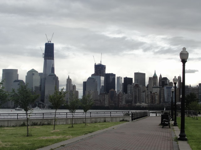
Ground Zero is a hard hat zone with multiple buildings under construction.  One World Trade Center will be the tallest building in NYC when the spire is added it will reach 1,776 feet above street level. 

The museum building will  utilize some of the salvaged steel beams from the original twin towers.  The park  surrounding the memorial fountains is a stunning place to reflect and remember.


St. Paul’s Chapel also has an amazing place in history for it was here on April 30, 1789 that George Washington came after taking the oath of office.  St. Paul’s new history is forever  entwined with the events of September 11, 2001 and is known as the chapel that stood.  The grounds covered with debris from the towers, it became the place of refuge for the firefighters and workers of ground zero.  Food and water were provided on the steps of the chapel and workers rested and slept on the pews.  George Washington’s pew box was used to administer medical assistance. 


At the park on Liberty Landing where the boat is docked stands a monument with the names engraved of New Jersey residents who lost their lives on 9/11.  The two walls are erected to sight across the Hudson where the view of the twin towers stood as landmarks on the waterfront.

Views from the marina at Liberty Landing.


Sunday, June 3, 2012

THE BIG APPLE!


Trip Day:
     91
Latitude:
  40°42.61 ' N 
Locks Today:
0
Miles Today:
     49
Longitude:
074°02.47' W
Locks Total:
8
Total Miles:
1,799
Location:
Liberty Landing - NYC


We were awakened at 5:00 a.m. by fishing boats passing, stopping at the docks for fuel and bait, and boats getting underway from the marina.  Once awake we decided to get underway as well and we went out the inlet with a steady stream of fishing boats of all sizes.  As we cleared the jetties we saw porpoise off the bow—always a good way to start the day!


We were thankful we had made the decision to stay in port the extra day and we were rewarded with perfect conditions of westerly winds at 12 kts, 3-4 ft swells and lots of sunshine.  It was a glorious morning and we motorsailed at 6.5—7 kts about a mile offshore in 60 ft of water. The first 10 miles our only hazard was the flocks of fishing boats.  We sailed our way through no less than 150 boats—this is serious fishing territory! 


We passed one beach town/city after another—welcome to the  Jersey shore!  By 8:30 we could see Coney Island skyline.  The winds had increased and by the time we approached Sandy Hook we had pretty rough seas—those gentle swells were now chop and whitecaps and we reefed the main.  This is the Eastern most point of our trip at 073°56.50 ' W.


Off the coast of Coney Island we had begun looking for the barge that was to carry the Enterprise up the river   today.  The website had indicated the barge would go   under the Verrazano Narrows Bridge at noon today—we went under the bridge at 11:45, but there was no sign of the Enterprise—we were disappointed. 


As we cleared the bridge and headed up the channel, the out-going current began to impact us.  We had a 3kt current against us as boat traffic began to get really heavy.  We almost hit a large timber drifting in the channel so we realized we also had to be on the look out for debris as well as boat traffic.  In the middle of the ferries, tugs pushing barges, sailboats, trawlers, and sightseeing vessels there was a group of kayakers.  Amazing!  We were living in the moment, taking it all in, watching with awe as The Lady came into view—this is a moment to remember and not take for granted. 
After dropping the main and furling the jib, we were down to 2 kts against the current, so we just watched the ferries carefully and enjoyed the views of the Statue of Liberty and Manhattan skyline!


Just as we entered the breakwater to Liberty Landing it began to rain - one more little challenge. This marina is on the Jersey side looking across at the battery. 
We had hoped to see Jersey Boys  tonight, but forgot there was no evening performance on Sundays.  Since the theater district is closed on  Mondays, it looks like no Broadway shows this trip. 

We are off to explore Liberty State Park which is 1,100 acres. 
Our day was AMAZING and we are so happy to be sharing our experiences with our family and friends - thanks to all of you who are sharing our adventure with us - we love you!

Find us on Google map at the Location address in the footer below.


Friday, June 1, 2012

Hunkered Down - Manasquan


Trip Day:
     89
Latitude:
  40°06.40 ' N 
Locks Today:
0
Miles Today:
       0
Longitude:
074°02.94' W
Locks Total:
8
Total Miles:
1,750
Location:
Manasquan,  NJ

Yesterday while we were underway we heard the Coast Guard responding to a VHF distress call of a boat taking on water  -  today we found this report on the internet.  “The Coast Guard rescued six people from a life raft after the 38-foot boat they were in ran aground and began taking on water in Barnegat Inlet Thursday morning.  Once the boat began to sink, the crew abandoned the vessel and boarded a life raft where they waited for assistance.  Following the rescue, the fishing boat floated off the jetty and sank, authorities said. ”  All the inlets from Atlantic City to Manasquan are marked un-navigable and dangerous on the charts—guess this proves the point!


Manasquan is known as a safe harbor for boats to come into from the Atlantic in severe weather conditions.  This is one of those days and we stayed in the marina watching the fishing boats return with stories about how bad the ocean was today.  The winds have been 20-25 kts with stronger gusts all afternoon making for a bouncy ride even though we are tied in our slip.  By 5 o’clock it was extreme high tide with the water over the finger pier of our slip so Ron checked all the lines and adjusted for the high water which means he will adjust again late this evening since the tidal range is five feet. 

 Other than a two mile walk this morning, Ron spent the day researching the New York Harbor, setting way points for markers on the chart plotter, and confirming marina choices for the next week; while Jean caught up on email, logging expenses and slideshow building duties.  We are closely monitoring the progress and route of the Space Shuttle Enterprise which is scheduled to be transported by barge from JFK to New York Harbor in the next three days, meaning we have a good chance of witnessing history as it happens. 

 So, we are hunkered down expecting continued high winds and lots of rain tonight.  Tomorrow the weather is suppose to clear and we hope to pull out by mid-morning, if the predictions are correct, and head to an anchorage off Coney Island.

See Manasquan Inlet on Google Map by clicking on our Location in the footer below.