Thursday, May 31, 2012

Manasquan, NJ


Trip Day:
     88
Latitude:
  40°06.40 ' N 
Locks Today:
0
Miles Today:
     53
Longitude:
074°02.94' W
Locks Total:
8
Total Miles:
1,750
Location:
Manasquan,  NJ

Today was an interesting and lo-o-o-ng day!  But first we must digress.  .  . Coming in the    Absecon Inlet late yesterday afternoon, Ron decided to switch fuel tanks since the tank we were running on was almost empty .  He switched tanks and about 30 seconds later the engine died,   not a comforting sound as one enters an inlet.  It restarted quickly, then shut itself down again.  Ron switched back to the old tank and it ran fine.  So, last night in the dark with his trusty flashlight Ron spent 2 hours, removed hoses to look for an obstruction, then bled the air out of the lines and managed to solve the problem.  He is handy to have around the house and the boat!

We awakened at 5:30 a.m. and had the motor running by 5:45—it purred like a kitten.  Our only problem was the FOG!  Our visibility was about 50 yards which had us questioning ourselves, but then one of the other sailboats at our anchorage  headed out, so we decided to go for it.  I know, the lemmings and the cliff, etc., but we do have a chart plotter and an  air horn.  We exited the inlet, headed up and ran about 2 miles offshore for about an hour before the fog lifted.  We motor sailed 6.5—7.00 kts and all was well until the wind began to shift and then we had choppy water on top of the swells.  After traveling 20 miles, our speed had slowed to 4.2 kts and we seriously considered turning around since we had over 30 miles to go—do the math.  Ron checked weather forecast and buoy data and we decided to continue and wait for the wind direction to change.  Long story short, conditions improved, although our wind was NE instead of NW as all sources forecasted.  As we approached Manasquan Inlet, we considered continuing to Sandy Hook, but decided against another 5 hours in the Atlantic today. 

 There was very heavy boat traffic in Manasquan Inlet, which is rock jetties with extremely strong currents adding a little excitement on top of the ocean swells. 

Needing fuel we approached a marina and the dockmaster indicated Ron should circle and come in on our starboard side.  We had a 3kt current and Ron  wasn’t about to come into a dock  with the current so he came in port side to—the dockmaster got the message, it’s my boat, my decision!  We are staying the night at Hoffman’s Marina simply because this place is CRAZY!

Wednesday, May 30, 2012

ATLANTIC CITY


Trip Day:
     87
Latitude:
  39°22.89 ' N 
Locks Today:
0
Miles Today:
     39
Longitude:
074°25.35' W
Locks Total:
8
Total Miles:
1,697
Location:
Atlantic City,  NJ

It wasn’t raining so we cast off lines at 5:30 a.m. before we even had a cup of coffee, wanting to head up the coast before the weather turned sour.  A couple of other boats were getting underway at the same time so at least we knew we had company for a little while.  Going out Cape May Inlet was one wild ride—there were large swells close to shore left over from the heavy winds yesterday.  Those swells converging together as the water was squeezed into the narrow inlet made for very, very rough water.  We tossed back and forth, things falling off walls and shelves, then once we cleared the inlet we were met with 2-3 ft gentle rolling swells.   We shortly realized our winds were northeast instead of the predicted southwest so Ron was on the computer checking sea buoy data further up the coast.  After an hour or so the winds began to shift further west and we settled into the rolling seas.  We were able to fly sails which helped stabilize and reduce the rolling, but then the winds died down and we got nothing from the sails.

We saw several boats on the same rhumb line about three miles offshore, but of course they all passed us and eventually fell out of sight.  


Normally we would be excited as the tall buildings of Atlantic came into view, but as we approached it was raining and somehow the view was just not that exciting.  Jean tried to keep the front window cleared with her trusty squeegee to give Ron better visibility as we headed into Absecon Inlet.  This inlet is quite wide, so although we had 4-5 ft swells, the current was with us and we had a smooth ride into the channel.  We anchored just before the first bridge to wait for the rain to end.


By four o’clock the weather had lifted so we were off in the dinghy, then caught the shuttle bus to the Boardwalk and the casinos.


Tuesday, May 29, 2012

CAPE MAY - Weather Day


Trip Day:
     86
Latitude:
  38°56.99 ' N 
Locks Today:
0
Miles Today:
       0
Longitude:
074°53.21' W
Locks Total:
8
Total Miles:
1,658
Location:
Cape May,  NJ

Predicted heavy winds prevented us from venturing into the Atlantic, so today is logged as a weather day.  We pulled into a marina, closed up the boat and ran the AC while Ron scrubbed the decks and Jean had laundry duty.  About 3:00 we hopped on our bikes for a quick tour of Cape May, dinner in town and a stop at the grocery.

As promised, Cape May had wonderful Victorian homes on tree-lined streets and brick sidewalks. The trim and porch wood carved details were stunning, especially when accentuated by brightly colored paint.


The shopping district, a series of row houses from the late 1800s, was  pedestrian only with benches along the brick roadway and plenty of shade provide by a variety of trees.  The picturesque scene was completed by hanging baskets of flowers and antique lamp posts.


The weather forecast point to lighter winds tomorrow so we plan to leave at the crack of dawn to run to Atlantic City, a distance of 39 miles.


Monday, May 28, 2012

CAPE MAY, NEW JERSEY


Trip Day:
     85
Latitude:
  38°56.99 ' N 
Locks Today:
0
Miles Today:
     48
Longitude:
074°53.21' W
Locks Total:
8
Total Miles:
1,658
Location:
Cape May,  NJ

Ship John Shoal Lighthouse
Rise and shine!  Ron lifted the anchor at 5:30 this morning so we could run with the current as much of the day as possible.  Little Reedy island gave us and one other sailboat good protection throughout the night.  As we got underway we realized the other boat was lifting anchor as well so at least two of us will be on Delaware Bay in the morning calm awaiting the sunrise.


At 9 o’clock we called Emma to wish her a Happy Birthday—she told us all about her gifts and seeing her cousins and having a friend spend the night—she brightened our day!

Most of the morning we ran the engine at 2,000 rpm, flew the sails and made 7.5 knots with the help of a 2.5 kt current in very light winds.  As we made our way east, Delaware Bay opened up wide with gentle, rolling waves as we passed groups of fishing boats in clumps around baitfish schools. Something was running the baitfish, but we never saw any boats with fish on, nor did Ron catch any as we trolled through the schools.


With the tip of Cape May in sight, Ron sighted porpoise—lots of porpoise.  It’s been quite some time since we have seen porpoise so he headed to the bow with the camera and the sleek, playful porpoise obliged him by running with us for a little while. 


As we approached the inlet, there was plenty of boat traffic and Memorial Day beachgoers.   The ferry was loaded as we passed and headed up Cape May Canal to the inner harbor selecting an anchorage just off the U.S. Coast Guard Station. 


The various weather sources predict high winds in the afternoon tomorrow, so we will most likely not venture into the Atlantic until Wednesday. 

The entire city of Cape May is designated a National Historic Landmark because it is noted for its large number of Victorian houses. 

So, tomorrow we will go into a Marina, give the boat a good cleaning, then hop on our bikes for a tour of Cape May - not a bad way to wait for fair winds!


Sunday, May 27, 2012

DELAWARE BAY


Trip Day:
     84
Latitude:
  39°30.81 ' N 
Locks Today:
0
Miles Today:
     22
Longitude:
075°33.98' W
Locks Total:
8
Total Miles:
1,610
Location:
Reedy Island, Delaware

Bohemia River was a peaceful overnight anchorage and we slept well.  We took our time getting underway, timing our departure with the current which is very strong in this area.  As we headed up the Elk River we felt it would be a great place for a summer cottage.  It was a protected waterway, but still wide enough to sail or power boat with quick access to the Chesapeake Bay.


 We entered the C&D canal with a 2 kt favorable current, but no wind so we were not able to sail.  As one would expect, we had lots of company on the water for Memorial Day activities. Boy is it HOT!

As we exited the canal and entered Delaware Bay we had plenty of wind, but it was directly on our nose and we were still not able to raise the sails.  It was early in the day so we decided to go further than planned and travel 12 more miles to the next anchorage.  We rounded a point where the Bay opened up, we had 12-14 kts of wind against and then realized we also had a 2-3kt current now against us.  After motoring for about an hour with our over-the-ground speed now having reduced to less than 3 kts we conceded—turned around and went back to Reedy Island to anchor for the night.  Soon after anchoring we had a Skype request from family and happily obliged—there was a Memorial Day pool party in full swing so we got to see the grandkids in action! 


We're so glad we still see Osprey nest on almost every marker. 


Saturday, May 26, 2012

HEADED NORTH - CHESAPEAKE, MD


Trip Day:
     83
Latitude:
  39°28.44 ' N 
Locks Today:
0
Miles Today:
     40
Longitude:
075°55.34' W
Locks Total:
8
Total Miles:
1,588
Location:
Bohemia River near Chesapeake City

We have NOT sailed off the edge of the world!   Jean has just been a slacker and failed to blog while we had friends onboard and toured Baltimore - too much food and wine may have played a role in this laziness.
One last look back at Baltimore Inner Harbor and the Baltimore Dragon Boat Club we sailed out the Patapsco River.


We headed north into The Bay which begins to  narrow as we near the head waters of the Chesapeake. 


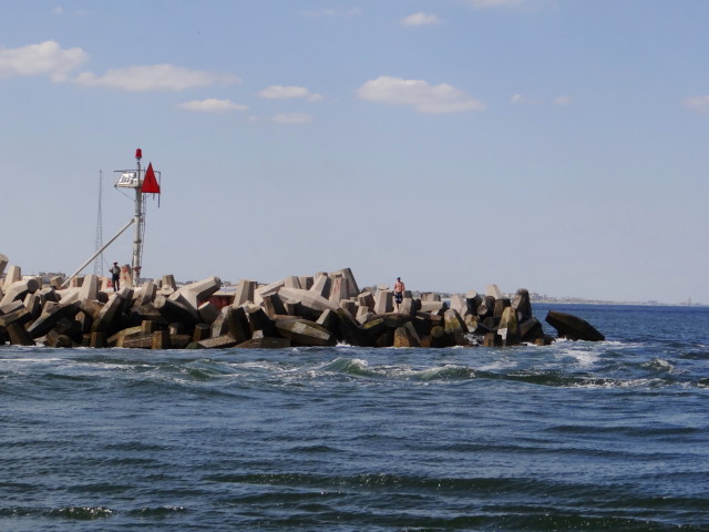
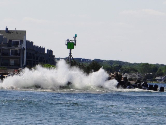
Lighthouse on Turkey Point and a happening shoreline along the Elk River.


Seven hours in the hot sun at the start of the Memorial Day weekend was hard today after being in a marina for two days.  The Chesapeake area boasts of being the sailing capital of the world and today I believed it because the ratio of sailboats to power boats was about 15:1!

We anchored in Bohemia River off the Elk River about 8 miles south of Chesapeake City which marks the entrance to the C & D canal.  Tomorrow we will bid Maryland goodbye as we pass into Delaware.  

Trip Day:
     82
Latitude:
  39°16.72 ' N 
Locks Today:
0
Miles Today:
       0
Longitude:
076°36.22' W
Locks Total:
8
Total Miles:
1,548
Location:
Baltimore Inner Harbor East

MAY 25, 2012  /  DAY 82  / BALTIMORE, MD


Meet our friends, Art and Mike from Sarasota.

It’s easy to be a tourist in Baltimore with plenty of   literature on museums, the aquarium, the zoo, historical sites, free bus shuttle and friendly locals. 

Of the four ships available to tour, we chose the sailing sloop of war Constellation, which is the only major U.S. Navy warship surviving intact today that saw active service in the American Civil War. 


The sloop Constellation is the second warship to bear the name, the first being a 36-gun frigate built at Baltimore from 1795-98.  This Constellation was built from 1853-55 at Gosport Navy Yard near Norfolk.  In the years following the War of 1812, the three masted, square-rigged sail sloop with 18-22 guns replaced the frigate as the principal type of  medium sized warship in the US Navy.


In 1858 the U.S. government increased the effort to catch American ships illegally smuggling slaves into Cuba, Brazil and the United States.  Constellation was the squadron flagship while fourteen American slave ships were captured off Africa and almost 4,000 people were freed and taken to safety in Liberia.  At the start of the Civil War in 1861 the squadron’s ships were ordered home and the anti-slave trade patrols ended.  One gun on the bow is still fired during tours with tourist participation to haul it into place at the rail.


After the war, Constellation was used as a Navy training ship in Newport, RI until 1955 when she was moved to Baltimore, where she underwent a major restoration from 1996-99.  Touring this vessel with a 14" thick hull, 3 mast,179' in length and 41' beam, gave us an appreciation of shipbuilding methods of these huge wooden vessels from the past.  Viewing the austere officer’s sleeping quarters and crewmen’s hammocks we returned to our boat with a greater appreciate of our creature comforts including a diesel engine!


MAY 24, 2012  /  DAY 81  / BALTIMORE, MD


We awakened early and walked to Chick and Ruth’s Deli for breakfast and we were lucky enough to be in time for the daily tradition of standing for the pledge of allegiance by staff and patrons. 
We got underway about 9:30 traveling east on the Severn River, then headed north on the Chesapeake passing under the Bay Bridge with a nice wind and a rising sun.  Sailing north, passing the Magothy River and Gibson Island, we turned west into the Patapsco River and headed toward Baltimore.  There was a steady stream of large, commercial vessels in the main shipping channel, but Art was in good form managing to steer clear. 
  Our initial impression of the Patapsco River was all about a large shipping port and industry.  We passed Fells Point, which in the day was the second busiest port of entry for immigrants after Ellis Island, and the cityscape came into view with Fort McHenry front and center.  


The excitement built as the buildings grew taller and the features of the harbor came into view, but it took all of us and the binoculars to determine just which marina was Harbor Side East.  Once located and a VHF call to the dock master for slip assignment Ron managed to maneuver the boat into the slip without incident although we questioned whether the slip was wide enough for our boat.   
It was only a short walk to Little Italy with a multitude of choices for dinner.


MAY 23, 2012  /  DAY 80 / ANNAPOLIS, MD
First order of the day was to get the boat clean, inside and out in preparation for friends arriving from Sarasota.  Ron scrubbed the outside while Jean readied the aft berths, washed linens and gave the inside a really good cleaning.  Mid morning we took a break and decided to check out the specialty crepes at Sofi’s— good decision, those crepes were delightful. 


Our return walk took us by the Alex Haley Memorial which is in a little park next to the city basin where Kunta Kinte arrived as a captured, chained slave to be sold at the Annapolis  market.  The city has done a nice job with the commemorative sculpture and bronze plaques honoring this time in history captured in Alex Haley’s series, Roots. 

Mike and Art arrived late in the afternoon having been met at the airport by their son, David, who lives in Baltimore.   In addition to their luggage they had a cooler full of wine and ice so they were welcomed aboard with gusto and glasses were poured.  David graciously drove us all to dinner at Level’s on Main Street, which specializes in small plate faire.  We ate our fill of lamb, tuna, calamari and fresh vegetables before returning to the boat.

Google Map us by clicking on Bohemia River MD in the Location Box in the footer below.

Tuesday, May 22, 2012


Trip Day:
     78
Latitude:
  38°58.55 ' N 
Locks Today:
0
Miles Today:
       0
Longitude:
076°28.93 ' W
Locks Total:
8
Total Miles:
1,520
Location:
Annapolis City Basin


After a few chores this morning we walked across the square and entered the grounds of the  Naval Academy which is impressive by anyone’s standards.  This is Commissioning Week and today’s activities include a band concert and the Climbing of the Herndon. 


The plebe (freshman) class form a human pyramid around the 21-foot tall Herndon Monument. Members of the class try to make it to the top to remove a plebe hat, or “dixie cup,” that upperclassmen have placed on the top of the obelisk. The midshipman then replaces the “dixie cup” with a midshipman’s.

The class of 2015 took 2 1/2 hours to accomplish the task—we watched the first hour.


Later in the afternoon we felt a bike ride around the historic area was in order.  There are many well-preserved homes from the late 1700s and 1800s.


The Maryland Inn was built in 1776 as a  tavern and inn and has remained an inn to this day.


Since its original charter in 1649, Maryland has always played an important role in    governmental affairs with Annapolis as it’s capital. 


The Maryland State House was built in 1772 and served as the Capitol of the United States from 1783-1784.  Today it is the oldest state house still in legislative use.  It was here that General George Washington resigned his commission before the Continental Congress in 1783, and in 1784 Congress ratified the Treaty of Paris to end the Revolutionary War. 


MONDAY - MAY 21, 2012


Rain is in the forecast for the next couple of days and we are watching TS Alberto off the South Carolina Coast.  The guys let us in on a local tip—breakfast at Chick and Ruth’s—where Ron had Eggs Benedict with Lump Crab Meat.  Oh yes, this little hole-in-the-wall deli serves up some great eats!  Each morning at 8:30 they salute the flag with the pledge of allegiance with full participation from staff and breakfast patrons


Vince, Tom, Ed and Bill from Philly


Unfortunately,  walking distance from the basin is mostly restaurants and tourist shopping.  So, another Enterprise rental gave us access to a hardware store, a real grocery store and an amazing mall—wow, we haven’t been to a mall in two months!  A good rainy day for walking the mall and picking up a few treasures to mail home to some special little people whose hugs are sorely missed. 

 Ron spent some time attempting to repair our shower faucet, after two trips in the dinghy to transport all our grocery and shopping bags to the boat.  A quiet night was in order after our four hours of walking and shopping.  We will bring the boat into a slip in the city basin tomorrow morning.